The total mean ice concentration has been calculated for the 7 areas and the 5 algorithms. The period is January and February 1993, and the results are shown in Table 2.
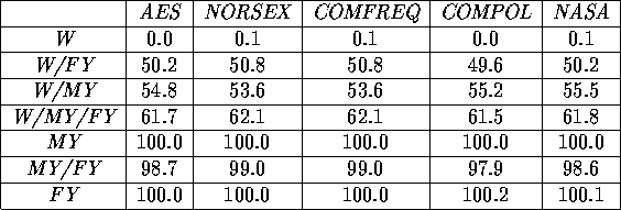
Table 2 Total mean ice concentration in January and February 1993 (in %)
It is seen, that all the algorithms are unbiased, i.e. the ice concentration in the W,
MY and FY areas are calculated close to the expected values of 0%,
100% and 100%.
Deviations on the first decimal are caused by the finite precision (1 decimal) of
the used SSM/I brightness temperatures.
In all other areas, the exact ice concentration is unknown, but it is seen, that all
algorithms give results within 2% of each other.
The daily ice concentrations in the tie-point areas are plotted in Figure 5
through 7,
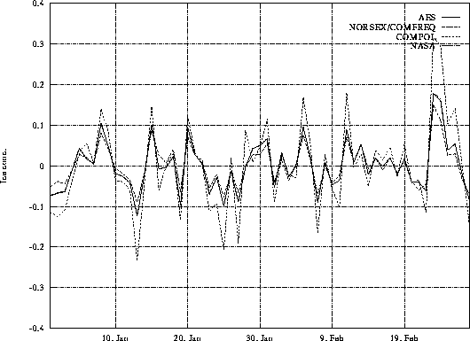
Figure 5 Ice concentration in open water area in Jan/Feb 1993
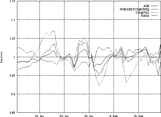
Figure 6 Ice concentration in multi-year ice area in Jan/Feb 1993
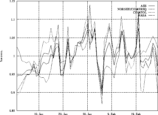
Figure 7 Ice concentration in first-year ice area in Jan/Feb 1993
and the standard deviations in the two-month period are shown in Table 3.
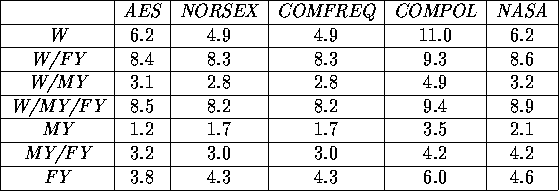
Table 3 Standard deviation on daily ice concentrations in January and February 1993
(in %)
In Figure 5, the ice concentration
in the open water area is shown. From the figure it is clear, that the COMPOL
algorithm has much more variance than the other algorithms. This is also evident
in Table 3.
All curves are having the same shape, with the only difference being the variance
from the 0% ice line. If it is assumed, that the open water area is actually
ice free in the period, the standard deviation on the ice concentration shows,
which influence the geophysical parameters have. In [Pedersen.,
1991, p. 90] it is concluded, that the most important geophysical parameters
in open water areas are cloud liquid water, water vapor and wind speed. The
higher frequency channels are more sensitive to these geophysical changes, and
this is probably the reason for the bad performance of the COMPOL algorithm
in this case.
Figure 6 shows the ice concentration
in the multi-year ice area. All curves are well correlated, and no algorithm
produces results outside a  8% wide range around the expected 100% ice cover. In the figures it can be seen,
that the NORSEX/COMFREQ algorithms, in several occasions responds opposite to
changing geophysical influence than the other algorithms, i.e. that the ice
concentration is decreasing in the NORSEX/COMFREQ algorithms while it is increasing
in the others. This is not observed in the open water case. Again the COMPOL
algorithm has the biggest standard deviation (Table
3 ), but it is not as bad as in the open water case. [Pedersen.,
1991, p. 92] concludes, that the important geophysical parameters in a multi-year
ice area are cloud liquid water and ice temperature.
8% wide range around the expected 100% ice cover. In the figures it can be seen,
that the NORSEX/COMFREQ algorithms, in several occasions responds opposite to
changing geophysical influence than the other algorithms, i.e. that the ice
concentration is decreasing in the NORSEX/COMFREQ algorithms while it is increasing
in the others. This is not observed in the open water case. Again the COMPOL
algorithm has the biggest standard deviation (Table
3 ), but it is not as bad as in the open water case. [Pedersen.,
1991, p. 92] concludes, that the important geophysical parameters in a multi-year
ice area are cloud liquid water and ice temperature.
The first-year ice curves are shown in Figure
7. Again all curves are well correlated, but the variance through the period
is almost 15%. The NORSEX/COMFREQ
algorithms have an opposite response in the beginning of the period. In [Pedersen.,
1991, p. 91] it is given, that the most important geophysical parameters
in first-year ice areas are cloud liquid water and ice/air temperature. This
is the same parameters as in the multi-year ice case, and the bigger variation
in the ice concentration is probably caused by changing ice conditions in the
period or changing cloud liquid water near the ice edge.
Table 3
shows the standard deviation in the period, and overall, it ranges between 1.2%
and 11.0%. It is seen, that the COMPOL algorithm always has the greatest standard
deviation. This is probably caused by the channel selection in the COMPOL algorithm,
which only uses channels at the 37GHz frequency, which is more sensitive to
the geophysical influence than the lower frequencies. The other four algorithms
have very similar standard deviations in the different areas. It has to be stressed,
that the standard deviations are influenced by changing ice conditions in the
two-month period, and the results are therefore only suitable for comparison
with other algorithms in the same area and period. Furthermore, it can't be
concluded, that the algorithm with the lowest standard deviation is the most
precise. Maybe it just can't follow rapid changes in ice conditions.
Tim Flintholm Fink<tff@emi.dtu.dk>