Figures 5-7 show daily thumbnail images of ice concentration from the US Defence Meteorological Satellite Programme's SSM/I (Special Sensor Microwave/Imager) instrument. The images are from the F10 and F13 platforms of the DMSP series of satellites.
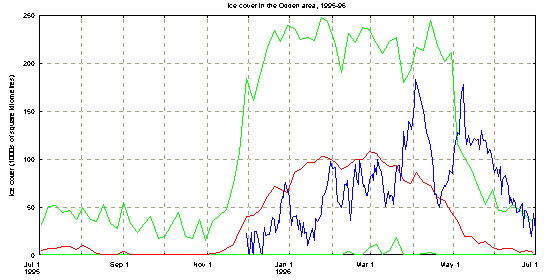
Figure 2 shows the daily area of ice cover contained in an 'Odden box' region of the central Greenland Sea which is shown as the white rectangles in Figure1 and Figures 5-7. The corners of this box are: (78.2N, 1.5W), (74.13N, 12.467E), (67.7N, 8.4W), (70.316N, 20.794W).
As can be seen from Figure 2, the ice cover is below average for most of the time until the middle of March. Then follows a period with well above average ice cover until a rapid decay in mid April followed by a period from early May where the ice cover is actually larger than the maximum of the previous 15 years (Toudal et al, 1996). It should be noted also, that the ice cover of the previous two winters was well below average all the time (Toudal et al, 1996). Thus, the general picture is of a large Odden ice tongue which did not develop to its full extent until remarkably late in the season.
Figure 2. Ice conditions in the Greenland Sea during the 1995-1996 winter (from passive microwave observations). The upper line shows maximum ice cover during the period 1978-1992, and the smoother middle curve shows average ice cover over the same period. The more variable curve shows the actual ice conditions during 1995-1996. The curve barely visible around Mar-May shows minimum ice cover during 1978-1992.
The ice cover within the 'Odden box' area, showed large variations during the winter. The first substantial ice growth period was at the end of December during the cold period (see section 3). The next maximum was around February 1 when approximately 100.000 km2 of ice was present. During February and March the ice cover varied between 50 and 100.000 square kilometres, around or below the average for this time of year. The last week of March and the first few days of April then saw the ice reach 183.000 square kilometres in extent followed by a rapid decrease with a minimum of 50.000 square kilometres reached on April 20. This means that 130.000 square kilometres of ice disappeared according to the microwave instrument over a period of 14 days. A new period of growth followed with a maximum of 178.000 square kilometres on May 8. In the following sections we will try to explain this large variability in more detail. Figures 3 and 4 show blow-ups of portions of Figure 2 for reference.
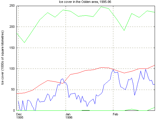
Figure 3. Ice cover in the Greenland Sea for the period December 1995 to February 1996 in 1000's of square kilometres. Derived from SSM/I passive microwave satellite observations. Plotted on top of maximum/minimum ice cover for the last 15 years (top curve/ very bottom curve), and average for same period (smooth curve in the middle).
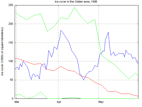
Figure 4. Ice cover in the Greenland Sea for the period March to May 1996, in 1000's of square kilometres. Derived from SSM/I passive microwave satellite observations.