
March was characterised by a period of moderate winds from the south in the first half of the month. They brought in warm air and the ice cover decreased. At the end of the month the winds (still moderate) came from the North, air temperatures dropped and ice started increasing. This continued into early April with the formation of a proper Odden feature on April 1-5. A minor storm on April 5 followed by winds from the East and above zero temperatures gradually removed most of the thinnest ice, and only scattered bands of the early April ice cover remained, primarily along the southern boundary of the ice covered area, when the German research vessel 'Valdivia' arrived in the region on April 21.
Figure 14. Daily air temperatures at Jan Mayen for March to May, 1996. The data are the 6-hourly air temperature observations collected at the Norwegian meteorological station on the island. Julian day 91 corresponds to April 1, 1996 at 00 UTC, 121 corresponds to May 1 at 00 UTC.

Figure 15. Daily sea surface temperatures at Jan Mayen during the period March 1 to May 31, 1996.


Figure 16. 6-hourly wind speed (above) and directions (below) at Jan Mayen during the period March 1 to May 31, 1996.
During the 'Valdivia' cruise, conditions were calm with air temperatures just below zero in the first week and between -5 and -10C during the second week. Temperatures measured at the ship were generally higher than at Jan Mayen, in particular during the latter part of the cruise when the ship was farther to the North (Figures 15-18). The cold and fairly calm period in early May saw a strong ice advance over a very large area of the Greenland Sea reaching a maximum on May 8 (Fig. 4) followed by a rapid drop then a more stable period with a heavy ice cover for the rest of the month (see Figures 4 and 6). In the afternoon of May 8, the wind went into the South, and temperatures increased to above the freezing point which caused rapid melting of the thinnest part of the recently formed ice. Temperatures around the freezing point for most of the latter part of May together with very calm winds were not sufficient to melt the more persistent part of the ice cover. As we shall see later, the ice cover in addition was supported by ice being advected into the area.
Figure 17 shows the normally high cloudiness of the area that makes AVHRR observations difficult at most times.

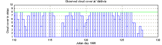
Figure 17. Observed cloud cover at Jan Mayen and at the position of German Research vessel 'Valdivia' (courtesy of Jan Backhaus). 8 means total cloud cover, 0 clear sky, and 9 is the value used when the cloud cover could not be observed.

Figure 18. Comparison of temperature observations at Jan Mayen (full curve) and the observations from 'Valdivia' (curve and markers) during late April and early May 1996.
Heat flux calculations were done by Jan Backhaus from the 'Valdivia' cruise to the Greenland Sea in late April and early May (Jan Backhaus, personal communication). They show that at the position of the ship (which was skirting the outer limits of the ice covered area), the ocean was generally gaining heat (although not very much) over that period. This should prevent local ice growth. However, a comparison with the meteorological observations at Jan Mayen (cloud cover and air temperatures) (see Figures 17 and 18 above) suggests that the cloud cover at the position of the ship was generally denser than at Jan Mayen, and that the air temperatures over the period April 25 to May 8 were generally 2-4 degrees lower at Jan Mayen than at the ship. The daily NOAA-AVHRR images (see section 4 and 5) supplied by the Danish Meteorological Institute for this study show the ice covered area to be rather cloud free most of the days during the same period, so there is good reason to believe that the heat fluxes calculated at 'Valdivia' are higher than those occurring in the area of the ice advance, and that local ice growth on these grounds cannot be ruled out as part of, or the whole reason for, the ice advance.