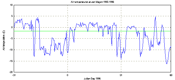
From Figure 10 it is seen that the daily air temperatures at Jan Mayen were well below the freezing point during most of the latter part of December, which corresponds with the early development of ice around January 1. Most of January saw above zero temperatures and the ice decayed. The cold period around February 1 corresponds to the second noticeable ice advance. February subsequently saw large temperature variability, and also the ice cover in the Odden area was quite variable.
Figure 10. Daily air temperatures at Jan Mayen for December 1995
and January and February 1996. The data are the 6-hourly air temperature
observations collected at the Norwegian meteorological station on the island.
Julian day 0 corresponds to January 1, 1996 at 00:00 UTC. The marked line
is at -1.8C, the freezing point of sea water.
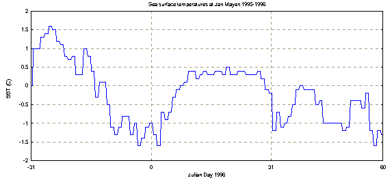
Figure 11. Daily sea surface temperatures at Jan Mayen for December 1995 and January and February 1996. The data are the 12-hourly SST observations collected at the Norwegian meteorological station on the island. Julian day 0 corresponds to January 1, 1996 at 00:00 UTC.
Winds were moderate for most of December and January, except for two events in late January that started by advancing the ice edge towards the east (winds from the west), and ended up bringing cold air in from the north. Subsequently, winds from east and southeast brought warmer air and ice retreat in early February. The end of February brought some severe storms with wind speeds up to 37 m/s being recorded at Jan Mayen. Most of the strong winds were from the north, and even though they scattered the ice field they brought in cold air.

Figure 12. 6-hourly wind speed observations at Jan Mayen for December
1995 to February 1996. Julian day 0 corresponds to January 1, 1996 at 00:00
UTC.

Figure 13. 6-hourly wind direction observations at Jan Mayen for
December 1995 to February 1996. Julian day 0 corresponds to January 1,
1996 at 00:00 UTC.
Figures 12 and 13 show observed wind speeds and directions at Jan Mayen for the period December 1995 to February 1996. Note that winds during the latter half of December were primarily from the north, whereas the positive temperature anomaly of January was caused by winds from the south. February shows more variable conditions with some storms from the north in the latter part of the month. Figure 11 shows the daily SSTs for the winter of 1995-1996, showing how the sea cooled to the freezing point during December but then warmed significantly to +0.4C during the month of January, with a second cooling period occurring during February such that freezing point was again attained by the end of that month. The correspondence between the shapes of the air temperature curve (Fig. 10) and the SST curve (Fig. 11) suggests that either the sea surface was responding rapidly to atmospheric heating and cooling or, more likely (since there is no obvious lag in the SST curve), that the island was positioned near a surface front which moved to and fro and which influenced the air temperature over the ocean.