| Øystein Wiig |
Erik W. Born |
Leif Toudal Pedersen |
| Norwegian Polar Institute Tromsø, Norway, and Zoological Museum, University of Oslo. |
Greenland Institute of Natural Resources Nuuk, Greenland |
Danish Center for Remote Sensing DTU, Lyngby, Denmark |
In
September 1994, two adult female polar bears were equipped with ARGOS satellite
transmitters. The transmitters were functional for 2 and 4 years respectively,
and a dataset on the mobility of East Greenland polar bears were collected.
A 25 Megabyte mpeg animation of the entire duration of the experiment has been constructed.
View animation.
A preliminary draft analysis of the sea ice distribution along the Greenland East coast during the period 1979 to 2002 can be found here.
|
|
|
|
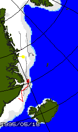
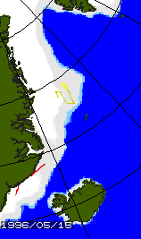
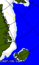
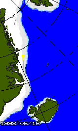
| Position of polar bears in mid
May 1995, 96, 97 and 1998 (red and yellow). The large coloured square is
the position, and the 'tail' line shows the movement during the past 30 days.
The grey lines in 1995 and 1998 shows the motion of drift buoys from the
Arctic Ocean Buoy Project. |
|||
A 25 Megabyte mpeg animation of the entire duration of the experiment has been constructed.
View animation.
|
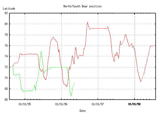
The bears moved thousands of kilometers. The plot below shows the latitude position of the bears during the experiment. The straight-line distance from 68 degrees North to 80 degrees North is more than 1300 kilometers, and one of the bears traveled this distance several times! The ice drifts southwards with the East Greenland Current along the East coast. Typical drift speeds are 15-25 cm/sec, corresponding to approximately 15-25 kilometers per day. The ice drift is slower during summer than during winter. Although, the southward movement of the bears is therefore easier to accomplish than the northward, the experiment showed that the bears had no problems moving against the southward drift of the East Greenland pack ice. The curves are flat (horisontally) when the bears are denning. This happened once for one bear and twice for the other. The bears denned in three different locations at the East Greenland coast. |
A preliminary draft analysis of the sea ice distribution along the Greenland East coast during the period 1979 to 2002 can be found here.