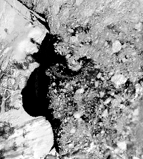
NOAA-AVHRR image of the North East Water on June 5, 1995
North East Water (NEW) Polynya project
DCRS contact:
Bj½rn B. Thomsen, e-mail: bbt@emi.dtu.dk
Leif Toudal, e-mail: ltp@emi.dtu.dk
Overall project description:
The North East Water polynya project is mainly a biological and oceanographic experiment carried out in order to obtain knowledge about the processes going on in this remote area.
Role and contribution of DCRS:
Short term polynya mapping
The objectives are to study the detailed formation and decay of the polynya. This
includes observations of ice motion, ice formation and ice melting in the polynya
area. A semi-automatic method is being used to track ice features in AVHRR and
ERS-1 SAR images. Latest passive microwave image of the polynya is available
here.
Long term polynya mapping using passive microwave observations
The objectives are to monitor the interannual variability of the polynya for a long time period using passive microwave observations from satellite. The microwave instruments allow daily observations on a coarse scale irrespective of cloud cover and daylight.
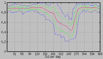
Average polynya development for the years 1979-1994, Red curve is Average, Green curves show +/- one standard deviation arount the average curve, and the blue curves are minimum and maximum ice extent at a perticular time of the year. Click on the image to download a postscript file containing the curves for each of the years 1978 to 1994.
Note: orientation is landscape
Active microwave Sea ice signatures
Leif Toudal <ltp@emi.dtu.dk>
Last modified: Mon Jul 10 14:05:09 1995
